Hugo Neighborhood Association & Historical Society
|
Hugo Neighborhood Association & Historical Society |
|
|
THOMAS BRYANT: HUGO PIONEER Brochure 8A in Hugo's Pioneers Brochure Series
May 17, 2008
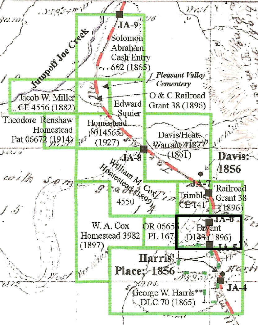
Quarry Section of Applegate Trail: 1856 Thomas J. Bryant: Military Warrant
Military Warrants Before the Civil War, veterans were given warrants entitling them to a specified number of acres of public domain land for service in military engagements. Hugo has three military warrants for military service. 1896 Thomas J. Bryant Military Warrant On January 18, 1896 Thomas Bryant was issued a military warrant for 80 acres along the Applegate Trail in Hugo, Oregon (Patent No. D143). The grant was under the authority of the March 17, 1842 Script or Nature of Scrip Act (5 Stat. 607).1 - 3 This 80 acres is two forties orientated east-west across Hall’s Draw. It is north and adjacent to the Harris donation land claim at approximately the location of today’s entrance to the Josephine County Sportsman Park entrance. The Thomas Bryant Family, Hugo Pioneers: ca., 1890s - 1910s Marriages Arvilla Bryant married G. J. Soleman August 17, 1904 (Vol. 5, p. 33). T. M. Bryant married Clara M. E. Soleman (daughter of J. T. Soleman) August 18, 1904 (Vol. 5, p. 34). Hall’s Draw Hall’s tombstone at the entrance to the park and the southern entrance to a draw in the general location of JA-5 and JA-6 is the rationale for the naming of the draw as Hall’s Draw.4 His warrant is a relatively late warrant as the good prairie and pasture land to the north and south in Schoolhouse and Harris creeks has been in private property since the early 1860s. The warrant does have a small tributary of Harris Creek which may have been perennial. Hall’s Draw also had a small amount of bottom land. Applegate Trail The Bryant warrant is exactly astride the Applegate Trail which is clearly depicted on the 2007 Josephine County Assessor maps: "Approx. Center Line Territorial Road Willamette Valley to Jacksonville." This same trail location is almost exactly the title used on the 1856 GLO map: "Road from Willamette Valley to Jacksonville" The trail continues north from the warrant through the Josephine County Sportsman Park, and to the northwest over I-5 down Schoolhouse Creek. General Land Office (GLO) Field Survey Notes For Applegate Trail
1895 Official Map of Josephine County There is a potential conflict as the Bryant warrant was issued in 1896 which is a year later than the 1895 county map which shows the land as being owned by W. H. Flanagan.5
In 1900 Thomas Bryant was a farmer; his son Thomas M. was a farm laborer. Pleasant Valley Cemetery8
Want more information? Contact an officer of the Hugo Neighborhood. ______________________________________________________________
|
|
© 2011 Hugo Neighborhood Association & Historical Society |