hnalogo.jpg (103481 bytes)


Hugo Neighborhood Association & Historical Society


Home
Up
Hugo Tombstone Quarry Section of Applegate Trail
Thomas Bryant: Hugo Pioneer
Bryant Family: Federal Censuses
J.C. Cochrane Family: Early Hugo Pioneers
William A. Cox Family: Hugo Pioneers
W.M. Cox Family:  Hugo Pioneers
John Davis:  Warrant Locator
W.H. Flanagan Family:  Hugo Pioneers
Harris:  Hugo Pioneers
Lewis Heatt:  Indian Fighter
Miller Family:  Hugo Pioneers
Jacob Miller Family:  Federal Censuses
Elizabeth F. Neely:  Hugo Pioneer
Neely Family:  Hugo Pioneers
Wm W. & E.J. Neely:  Hugo Pioneers
Pleasant Valley School
PVC: Applegate Trail & Pleasant Valley Cemetery
PVC:  Neely & Trimble Cemeteries
PVC:  Pleasant Valley Cemetery: 1870s?
PVC:  Tombstone Analysis
Renshaw Family:  Hugo Settlers
Squier Family:  Hugo Settlers
Samuel Trimble:  Hugo Pioneer


SAMUEL TRIMBLE:  HUGO PIONEER

Brochure 81 in Hugo's Pioneers Brochure Series

Part of the 1.5 mile Applegate Trail Nomination to Federal Register of Historic Places

May 13, 2008
by
Hugo Neighborhood Association & Historical Society
Josephine County Historical Society
Rogue Advocates

wpe7.jpg (137930 bytes)

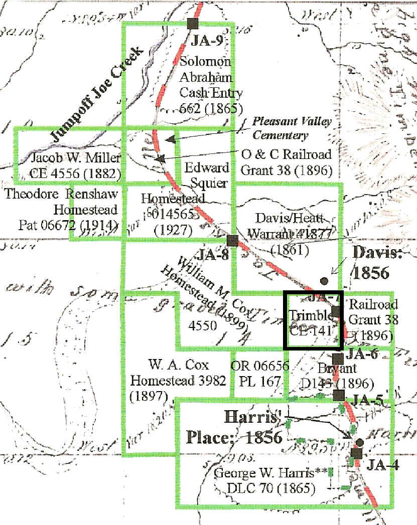
Quarry Section of Applegate Trail: 1856

Samuel Trimble

1864 Samuel Trimble’s Hugo Cash Entry On October 20, 1864 Samuel Trimble was issued a cash entry patent for 40 acres in Hugo, Oregon (Patent No. 141).1-2 This acreage was purchased three years after Robert and Clementina Trimble purchased the Turner 169.89 acre military warrant which was approximately two miles north of Samuel’s cash entry. Both tracts had the transportation access of the Applegate Trail, the only through road in northern Josephine County.

The relationship between Samuel and the Robert and Clementina Trimble family is unknown.

1861Turner Military Warrant "Military Bounty Land Act of March 3, 1855, Roseburg, Oregon. May 9, 1861 Military Warrant #92568 in the name of Rice Benson has this day been located by Anson Turner..."

Turner sold the warrant to Robert Trimble one day after he received it from the United States.

Samuel Trimble, A Hugo Pioneer: ca., 1860s - 18??

Hall’s Draw Why did Trimble purchase 40 acres at the north end of Hall’s Draw?7 His cash entry is a relatively early purchase about the same time the good prairie and pasture land to the north and south in Schoolhouse and Harris creeks were being located.

Applegate Trail The Trimble cash entry was located on the Applegate Trail which is clearly depicted on 2007 Josephine County Assessor maps for the forty.

"Approx. Center Line Territorial Road
Willamette Valley to Jacksonville."

This same trail location is almost exactly the title used on the 1856 GLO map.

"Road from Willamette Valley to Jacksonville"

The trail continues through the park to the northwest over I-5 down Schoolhouse Creek.

JA-7 The GLO field survey note JA-7 is located in the 40 acre cash entry. Two other GLO survey points are located close to the south.

General Land Office (GLO) Field Survey Notes For Applegate Trail

1856 GLO Field Notes: JA-5 - JA-78
Harris Road 2 (Creek) JA-5 22.50 Chains
Harris Road 3 (Pond) JA-6 37.00 Chains
Harris Road 4 (Office) JA-7 55.00 Chains

Page 9. Subdivisions of Township No 35 South of Range No 6 West North Between Secs 13 & 14

Chains
14.25 Stream 5 Links wide C West
18.00 Leave Field C N10W & S10E
22.50 Jacksonville Road c N 10 W& S10E
37.00 Same Road [Jacksonville Road] c N 10 W& S10E
39.00 to Swale C N10E & S20W
40.00 Set qu Sec Post, (From Which)
a Oak 8 in dia] bears N 5??E 19 Lks
a do] 12 da S 42W 5 ls
44.00 Top of ???
55.00 Same Road [Jacksonville Road] c N 80 W
59.92 Mr. Ham’s [?] Home bears N72W about 8
chains distance
80.00 Set Post Cor to Secs 11.12.13.&14

All three of the GLO points have been located in the field.

Want more information? Contact an officer of the Hugo Neighborhood on how you can become involved in your community history and land use.

______________________________________________________________

1. Bureau of Land Management (BLM), General Land Office (GLO) Records. 2007. Official Federal Land Records Site (http://www.glorecords.blm.gov/). Internet.
2. Hugo Neighborhood. 2007. Hugo Pioneers. Map Of Federal Land Transfer in Hugo, Oregon. Hugo, OR.
3. Josephine County Abstract Co. 1946. Abstract Of Title To NE ¼ Of NE ¼ Of Section 3, T.35S. R.6W. No. 3117, No. 20087, & No. 2558. Grants Pass, OR; Hugo Neighborhood. 2002. Dickerson’s Corner: 1945 - 2002. Brochure. Hugo, OR.
4. Hugo Neighborhood. 2007. (Trimbles: Military Warrant; Trimbles: Hugo Pioneers; Trimbles: Josephine County Census; Eurydice Trimble Crockett: Hugo Pioneer; Samuel Trimble: Hugo Pioneer). Hugo, OR.
5. Hugo Neighborhood, Josephine County Historical Society, et. al. 2007. Hugo Granite Tombstone Quarry Site: Preliminary Resource Assessment. Two volumes. Hugo, OR.
6. Hugo Neighborhood, Josephine County Historical Society, et. al. 2007. Assessment Of Proposed Pioneer Meadow Subdivision Containing Applegate Trail Resources. Hugo, OR.
7. Hugo Neighborhood. 2007. Lewis Heath: Indian Fighter. Hugo, OR.
8. General Land Office. 1856. Subdivision Lines T. 35 S. R. 6 N. GLO Field Notes For 1856 GLO Map: T. 35S., R. 6W., Willamette Meridian.


Back to Top  

© 2011 Hugo Neighborhood Association & Historical Society