Hugo Neighborhood Association & Historical Society
|
Hugo Neighborhood Association & Historical Society |
|
|
HARRIS: HUGO PIONEERS Brochure 28 in Hugo's Pioneers
Brochure Series
Quarry Section of Applegate Trail: 1895
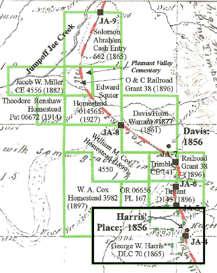
George & Mary Harris Donation Land Claim (DLC) 1853 Oregon Trail or Applegate Trail? George W. Harris and his family had crossed the plains from Tennessee to Oregon in 1853. 1855 The Harris family moved from the Willamette Valley to their DLC on what would become Harris Creek in 1855.1 1865 Harris DLC From 1855 the Harris family proved up DLC Patent No. 70 for 320 acres in Josephine County, Oregon. It was issued December 9, 1865 to George W. Harris Heirs of Harris and Mary Ann Harris.2-4 Applegate Trail The Applegate Trail was in the eastern portion of the DLC. It is clearly depicted on 2007 Josephine County Assessor maps for the old Harris DLC.
This same trail location is almost exactly the title used on the 1856 GLO map. "Road from Willamette Valley to Jacksonville" The trail continues north from the DLC paralleling I-5 to the draw at the entrance of the Josephine County Sportsman Park, through the park, and to the northwest over I-5 and down Schoolhouse Creek. The George Harris Family, Hugo Pioneers: 1855 - 1855 Natural Prairie & Pasture5-6 A significant portion of the donation land claim was open the wetlands of the upper Harris Creek drainage. The Harris ranch’s location had a reason: natural sub-irrigation for pasture during the winter, spring, and early summer. Naturally irrigated pasture was crucial prior to pumps, electricity, and sprinkler irrigation. Rogue Indian War: 18551 & 7-8 Thirty-five year old George W. Harris was killed by Indians on October 9, 1855 during the Rogue Indian Wars. His wife, Mary Ann, was able to drag her husband inside their cabin and barricade the door. The courageous woman, though never having used a gun before was instructed in its operation by her dying husband, and held off the raiders throughout that day. The next day she and her 11-year old wounded daughter, Ann Sophia, were rescued by a small group of U. S. Dragoons from Fort Lane, along with a couple dozen volunteers from Jacksonville. She had lost her husband, her 9-year old son, David, and a school teacher, Frank Reed, who lived with them and worked part time on the farm as a hired man. After the rescue her husband was buried in a grave dug in the center of their cabin. The cabin was set to fire and Mary and her daughter were taken to Jacksonville. 18711 & 7-8 She returned to the site of her nightmare experience only one more time. In 1871 she accompanied a group who went to the location of the burned down Harris cabin to dig up her husband’s body for re-burying in the Jacksonville Cemetery. Rogue River Indian War: 1855 1882 Mary Ann Harris passed February 17, 1882. 1 & 7-8 GLO Field Survey Notes: JA-49 The Applegate Trail is located on the Harris DLC near the old Harris home location. JA-4 has been located in the field.
Want more information? Contact an officer of the Hugo Neighborhood on how you can become involved in your community’s history and land use.
|
|
© 2011 Hugo Neighborhood Association & Historical Society |