hnalogo.jpg (103481 bytes)


Hugo Neighborhood Association & Historical Society


Home
Up
Hugo Tombstone Quarry Section of Applegate Trail
Thomas Bryant: Hugo Pioneer
Bryant Family: Federal Censuses
J.C. Cochrane Family: Early Hugo Pioneers
William A. Cox Family: Hugo Pioneers
W.M. Cox Family:  Hugo Pioneers
John Davis:  Warrant Locator
W.H. Flanagan Family:  Hugo Pioneers
Harris:  Hugo Pioneers
Lewis Heatt:  Indian Fighter
Miller Family:  Hugo Pioneers
Jacob Miller Family:  Federal Censuses
Elizabeth F. Neely:  Hugo Pioneer
Neely Family:  Hugo Pioneers
Wm W. & E.J. Neely:  Hugo Pioneers
Pleasant Valley School
PVC: Applegate Trail & Pleasant Valley Cemetery
PVC:  Neely & Trimble Cemeteries
PVC:  Pleasant Valley Cemetery: 1870s?
PVC:  Tombstone Analysis
Renshaw Family:  Hugo Settlers
Squier Family:  Hugo Settlers
Samuel Trimble:  Hugo Pioneer


W.H. FLANAGAN FAMILY:  HUGO PIONEERS

Brochure 22 in Hugo's Pioneers Brochure Series

Part of the 1.5 mile Applegate Trail Nomination to Federal Register of Historic Places

May 12, 2008
by
Hugo Neighborhood Association
Historical Society
Josephine County Historical Society
Rogue Advocates


Hugo’s Pioneers

W. H. Flanagan
Born: 1860 Ohio
Father’s Birth Place: Unknown
Mother’s Birth Place: Tennessee
Viola S. Flanagan
Born: 1871 Oregon
Father’s Birth Place: Missouri
Mother’s Birth Place: Tennessee

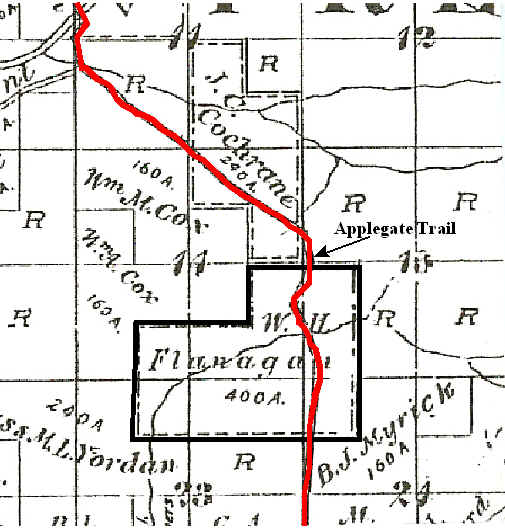
1865 Harris DLC From 1855 the Harris family proved up DLC Patent No. 70 for 320 acres in Josephine County, Oregon. It was issued December 9, 1865 to George W. Harris heirs of Harris and Mary Ann Harris.1-2

1896 Thomas J. Bryant Military Warrant On January 18, 1896 Thomas Bryant was issued a military warrant for 80 acres along the Applegate Trail in Hugo, Oregon (Patent No. D143).1-2

The W. H. Flanagan Family, Hugo Pioneers: ca., 1890s - 19??

1895 By W. H. Flanagan owned the old Harris DLC, and the 80 acre Bryant military warrant totaling a 400 acre ranch in the Harris Creek drainage.3 The main route through northern Josephine County went through the ranch.

W. H. Flanagan was a physician. Buried Masonic.

wpe7.jpg (45051 bytes)

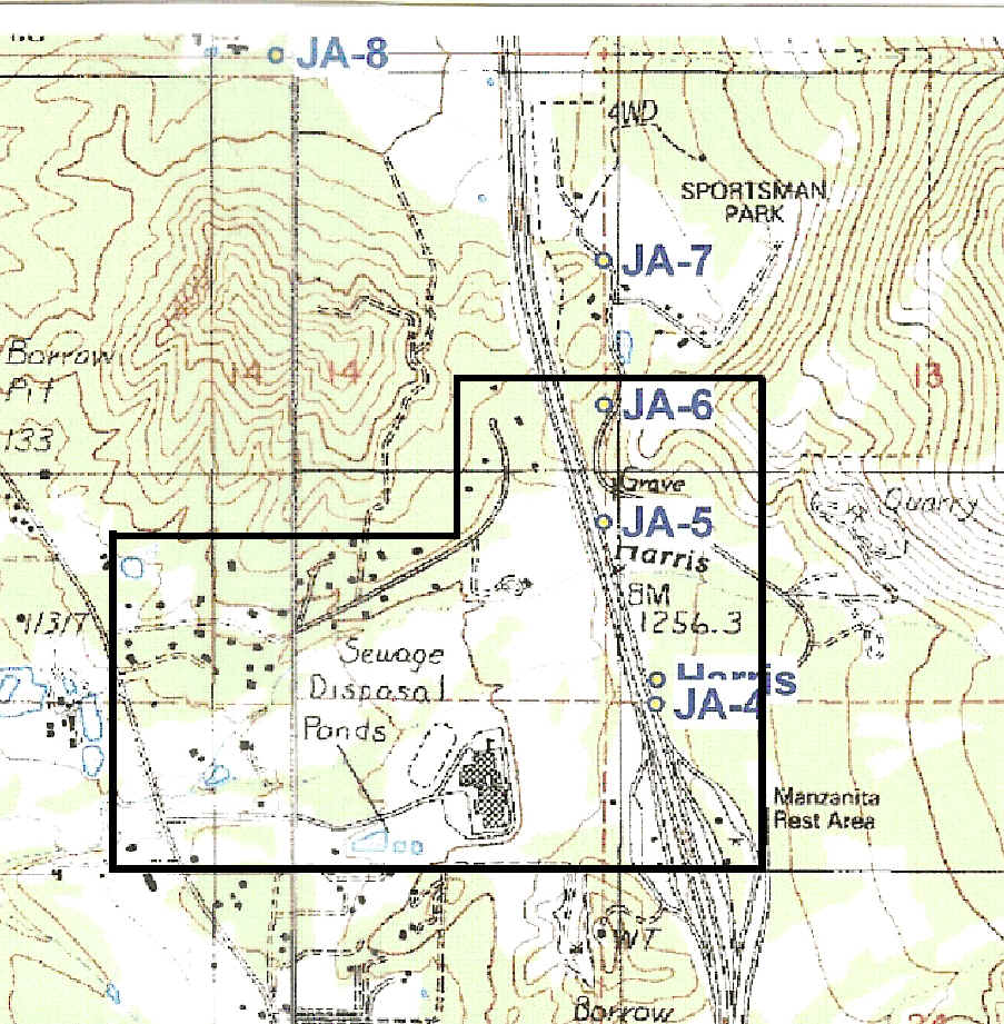
W. H. Flanagan's 400 Acre Ranch: 1895

Applegate Trail Through Harris Creek Drainage

1998 The 1998 USGS topographic Merlin Quad-rangle map covers the old W. H. Flanagan Ranch.4

wpe8.jpg (149876 bytes)

Old 1895 W. H. Flanagan Ranch
On Modern Topographic Map: 1998

Want more information? Contact an officer of the Hugo Neighborhood on how you can become involved in your community’s history and land use.

______________________________________________________________

1. Bureau of Land Management (BLM), General Land Office (GLO) Records. 2007. Official Federal Land Records Site (http://www.glorecords.blm.gov/). Internet.
2. Hugo Neighborhood. 2007. Hugo Pioneers. Map Of Federal Land Transfer in Hugo, Oregon. Hugo, OR.
3. Koch, Joseph , Draughtsman. 1895 Official Josephine County, Oregon. Map. Scale 1 inch = 1 mile. Meston - Dygert Book M’F’G. Portland, OR.
4. U.S.G.S. 1998. Merlin, OR 1998. Merlin Quadrangle: 7.5 minute topographic series, scale 1:24,000, and contour interval 40 feet. Denver, CO.

Back to Top    

© 2011 Hugo Neighborhood Association & Historical Society