Hugo Neighborhood Association & Historical Society
|
Hugo Neighborhood Association & Historical Society |
|
|
WHITE'S PLACE & APPLEGATE TRAIL May 18, 2006
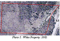
History Homesteaders. George T. McCormick homesteaded 80-acres that would become the White place (Figure 1 & Photo 1). His application number was 5029 for which he received a patent (No. 3164) in 1893. The Applegate Trail’s location was through the homestead. In 1895 George’s neighbor was another homesteader, Hugo Garber (i.e., Hugo’s namesake - Figure 1). 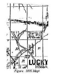 Owners of the White Property2
White’s Place 1960/1961 The White family arrived in Hugo in the early 1960s: father Walter, mother, Elaine, and sons John, Tom, Wyman, and Jeff.3 Since they arrived the land around the White home had been grassland and old walnut orchards.
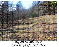
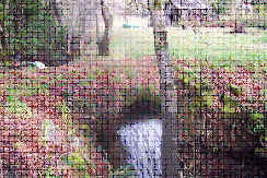
An old concrete culvert was there which always had a pretty good hole downstream where the White brothers, Jeff and Wyman, had found wagon artifacts (e.g., wood barrow stays and hoops, wooden spoke wagon hubs, iron with wood spokes, etc.). The brothers had grown up with an old road (Photo 2 - title page) going east-west across the entire 80-acres. It was a narrow, winding, relatively level roadbed on a moderate slope. This very old roadbed could be the old emigrant wagon road before the cutoff. East of the culvert crossing are some cement slabs where old-timers had told Jeff and Wyman they had parked the stage coaches (Photo 3). In this area the White family found many items associated with a stage coach line (e.g., old tackle, iron buckles, horseshoes, etc.). There used to be three barns similar to the one still standing on the property. More Information The lower part of the White’s old drive way was east and up slope of present day Hasis Drive. Parallel to the driveway was the postal telegraph line with the triangular split poles, including cross members, and glass insulators. The junction of White’s old driveway with Hugo Road is today the green gate driveway. Jeff found a 1910 dime here while waiting for the school bus.
Do you have information about the White place? Please share it with Wyman White and/or the Hugo Neighborhood.
Would your like to get involved in the history or land use of the Hugo area? Contact an officer of the Hugo Neighborhood for more information.
|
|
© 2011 Hugo Neighborhood Association & Historical Society |