Hugo Neighborhood Association & Historical Society
|
Hugo Neighborhood Association & Historical Society |
|
SETTLEMENT SETTINGS ASSESSMENT Of PROPOSED PIONEER
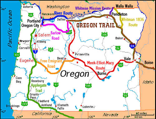
MEADOWS SUBDIVISION IV.F.7. Settlement Settings a) Applegate Trail: 1846 - 1913 Cultural routes represent historic roads that evolved through necessity or tradition. While it is possible some cultural routes may have a documented rationale, many will not have the design and construction legacy of an aesthetic or engineered route. It is possible, and likely, later additions or alterations may be well documented. These may be roads that evolved from animal, Native American, or pioneer trails, or simply logical connections between villages or through difficult terrain. Roads through mountain passes (i.e., Sexton Mountain Pass) or water gaps, paralleling the foot of mountains or following a line of stable soils or river courses are typical of cultural routes. Additional types of cultural routes may include a footpath between farms or to a resource site (i.e., sand, clay, timber or stone) that ultimately became roads. Cultural routes, in use as roads today, generally exhibit the greatest number of historic periods or layers. Beneath the modern pavement are potentially rich archaeological sites representing not only people and cultures over the years, but also the history of the very route— evidence of a cut bank to avoid sidling in the 1850s, remnants of an old macadam road from ca., 1910 - 1920, and other early highway improvements such as the 1922 paving at Sexton Mountain (i.e., 5-inch bituminous pavement 13 feet in width, with 7-inch concrete shoulders 2˝ feet in width on each side). For cultural routes it is important to understand these layers as you make a determination as to the period or periods of significance that are worthy of preservation. Remember too, subsequent layers of the road may embody the characteristics of aesthetic or engineered routes. (1) Legislative Recognition The NHTs did not follow single routes, rather numerous branches and cutoffs were used by the emigrants heading west. As designated by Congress in the NTSA, the Applegate Trail was the Southern Road to Oregon and is a branch of the California National Historic Trail.
Illustration IV-1 Oregon-California Trails Association Map SEC. 5. [16USC1244] "(18) The California National Historic Trail, a route of approximately five thousand seven hundred miles, including all routes and cutoffs, extending from Independence and Saint Joseph, Missouri, and Council Bluffs, Iowa, to various points in California and Oregon." Hugo is blessed with a rich heritage of historic roads, rough though they were. The Hugo Emigrant Trails Committee was formed to bring together all those who want to learn more about the early transportation in the area, from the casual admirer to the dedicated researcher. The California National Historic Trail and its Applegate Trail branch are administered by the National Park Service. The State of Oregon recognizes the value and significance of its historic trails, including the Applegate Trail, ORS 358.057(3) - The Applegate National Historic Trail. (2) Historic Applegate Trail During the first two decades of the nineteenth century, the only non-native peoples in the Oregon Territory were explorers, fur trappers and missionaries. The Hudson Bay Company had a string of forts or trading posts along the Oregon Trail from Independence, Missouri west to Ft. Vancouver on the Columbia River. The Oregon Territory included all of the current states of Oregon and Washington, and parts of Idaho, Wyoming and Montana. The trials and tribulations which the emigrants experienced coming west on the Oregon Trail, are well documented. The three Applegate brothers, Jesse, Lindsay and Charles along with their extended families, came to the Willamette Valley in 1843 via the Oregon Trail. After traveling over 2,000 miles, they came to the last obstacle in their journey, the Columbia River. While rafting down this turbulent river, three lives were lost. Jesse and Lindsay Applegate both lost their 9 year old sons, Edward and Warren, respectively, to this river when their raft capsized. Also killed was 70-year old Alexander Mac (Uncle Mac). For many years, the new American arrivals to the Oregon Territory were suspicious of the British. The British and the American governments had proposed different northern boundaries for the Oregon Territory but nothing was as yet decided. Both entities co-occupied this region. In 1846, it became apparent that a new non-British southern route out of the Oregon Territory was needed. The Applegate brothers were not only convinced that an escape route to the south was necessary in case war broke out with the British but they longed to find an alternative southern route which would avoid the life threatening Columbia River. Several expeditions were organized but were unsuccessful due to impassable rivers and creeks which forced the men to return to their homes. On June 20, 1846, The South Road Company organized again to explore and find a trail from the Willamette Valley over the Cascade Mountains to near Ft. Hall on the Snake River, which was suitable for covered wagons. The South Road Company included Jesse and Lindsey Applegate, along with Levi Scott and others from previous expeditions. The plan was for the South Road Company to locate the best southern route and solicit the traveling emigrant trains to provide at least 30 good-outfitted men to build the road ahead of their wagon train. On August 9, 1846, a large group of wagons set out west from Fort Hall to travel the new Applegate Trail for the first time to the Willamette Valley. By mid-October 1846, the emigrants were traveling up the south rugged mountainous terrain on the Trappers’ Trail toward the unnamed Mt. Sexton Pass. In the year 1853 over 3,500 men, women and children took this route which today is the basis for the state’s major transportation routes. (3) Harris Creek Prairie and Cochrane Wet Area For purposes of this analysis the open area along Harris Creek (Map 5; Map 16; Map 21; Aerial Photo 1) in JASec 2 is identified as the Harris Creek Prairie and the open area in upper Schoolhouse Creek (Map 16; Map 20; Aerial Photo 1; Aerial Photo 2; Aerial Photo 3B) in JASec 3 is identified as the Cochrane Wet Area. These two open areas had been open during the historic period in Oregon starting in 1856 and before. They are based upon the long-term factors of geology and soils. Both open areas are predominately two soils: 12B Brockman cobby clay loam, 2 to 7 % slopes and 18B Copsey clay, 3 to 7 percent slopes (see Section IV.B.; Map 15). Both meadows soils have similar characteristics: they are seasonally wetlands in the winter and spring and their properties limit effective rooting depth and plant growth (i.e., few trees and brush). These open areas during the opening of the Applegate Trail in the last 1840s would have been ideal in the late dry summer months – prairie-like areas with few trees requiring a minimum of manual labor clearing a wagon road. (4) Applegate Trail And Proposed Pioneer Meadow Subdivision The Applegate Trail, as the main north-south route through Josephine County, remained stable for over 60 years in the location of the Proposed Pioneer Meadow Subdivision from 1846 through ca., 1900 - 1913. The first automobile in Grants Pass arrived in 1904. A little more than a decade later, in 1915, Josephine County’s automobiles numbered 266. There was one car for every 34 persons in the county. The 1856 General Land Office survey and map and the 1895 Josephine County map depict the Applegate Trail location in the same area of the Proposed Pioneer Meadow Subdivision (Map 6; Map 7; Map 8; Aerial Photograph 2). In 1895 transportation technology had not changed from 1856 and there were no automobiles in the county. The 1856 Applegate Trail is clearly depicted on current assessor maps (Map 2C; Map 3A; Map 18; Figure 3 - Tax Lot Map from Galli Group testimony1) in 13 tax lots on the Jacksonville Road Section 3 of the Applegate Trail. The trail is identified as "Approximate Center Line of Territorial Road" on Map 3 and Galli Group Figure 3. There is more information on Map 2: "Approx. Center Line Territorial Road Willamette Valley to Jacksonville." This second title is almost exactly the title used on the 1856 map (Map 5; Map 6): "Road from Willamette Valley to Jacksonville" Maintaining the Territorial Road was unique as the main effort of the 1849 - 1859 Oregon Territorial Government which was for landowners to build local ways adjacent to their holdings — in the main, farm-to-market roads established to give farmers access by horse and wagon to trading centers and rail points. With the slogan, "Get Oregon Out of the Mud," the 1913 Oregon Legislature established the Oregon Highway Department. In 1914 the Oregon Highway Commission adopted a general highway map which included a trunk identified as the Pacific Highway from Portland to Ashland and the California border (see Section IV.7.f)). It is assumed that sometime in the 1910s a macadam road was developed in the general location of the today’s Monument Drive between the Pleasant Valley Cemetery and the location of today’s Merlin I-5 interchange. A portion of that macadam road remains just east of Monument Drive and south of Schoolhouse Creek (Aerial Photograph 2). This road cut off the old Applegate Trail segment between today’s Josephine County Sportman’s Park and the Pleasant Valley Cemetery. By 1921 the cutoff was official as the Pacific Highway was paved between the Pleasant Valley Cemetery and the location of the Merlin I-5 interchange (today’s Monument Drive). The 1933 Metsker map shows no hints of the Applegate Trail in Section 14 (Map 11). The lack of the trail on the 1933 Metsker map is unusual as it normally identified all local roads, even driveways, in sparsely settled rural areas, and the road was still clearly visible on a 1940 aerial photograph (Aerial Photograph 1). (4) Summary The 1856 Applegate Trail as the main north-south route through Josephine County remained stable for over 60 years in the location of the Proposed Pioneer Meadow Subdivision. In 1992 Congress established the California National Historic Trail of which the Applegate Trail is a branch. The State of Oregon recognizes the value and significance of its historic trails, including the Applegate Trail - ORS 358.057(3).
1. The Galli Group. August 2006. Subdivision Tentative Plan Application Items Pioneer Meadows Subdivision Grants Pass, Oregon. Figure 3 - Tax Lot Map. For Josephine County Planning. Grants Pass, OR. |
|
© 2012 Hugo Neighborhood Association & Historical Society |